
Gusty winds will make the temperature feel well below zero Friday evening, the night before Christmas Eve. Some municipalities are offering warming stations where residents can warm up and charge their phones amid the widespread power outages.
The strongest winds were recorded in New Haven County, according to the National Weather Service, where winds hit 64 mph at Lighthouse Point in New Haven. Winds of 40 to 50 mph were recorded throughout other parts of the state. Nearly two inches of rain fell on parts of the state, leading to widespread reports of flooding, particularly along the shoreline.
The worst of the storm in Connecticut moved through Friday morning, according to National Weather Service meteorologist Bill Leatham.
“All of the heaviest rainfall has pretty much moved off,” Leatham said Friday morning. There will be some showers Friday afternoon and possibly snow showers as the temperatures drop, Leatham said.
An official with Eversource, the state’s largest electrical utility, said the company has “hundreds of crews on the ground working,” and acknowledged that power restoration “will take time,” without providing a specific timeframe for when all of the outages will be restored.
Doing so comes with some urgency, as temperatures are forecast to plummet into the teens or lower Friday night, with wind chill values well below zero.
“We know the timing of this storm couldn’t have been worse as people are trying to prepare for the Christmas holiday,” Steve Sullivan, president of Eversource Connecticut, said in a statement Friday afternoon.
In a text message to customers Friday evening, the company said hundreds of crews are working with more arriving from out of state.
“With outages so widespread, full restoration will take time. Bitter cold tonight could cause flash freezing and make travel to repair sites difficult,” the message said.
Some municipalities have begun opening warming centers as the temperatures dropped Friday afternoon.
The weather service issued a coastal flood warning and high wind advisory with heavy rain and wind gusts that could reach 60 mph in the forecast for Friday.
The rapidly dropping temperatures on Friday could cause the precipitation to change to snow in some areas and a flash freeze is possible on roadways and untreated surfaces, the weather service warned.
“We are going to see temperatures plummet around dusk on Friday evening, and these wet conditions could freeze over very quickly,” Gov. Ned Lamont said Friday.
“When this happens, roads are going to get icy,” the governor continued. “Transportation crews are unable to pre-treat the roads at the moment because the heavy rainfall that we are experiencing right now would just wash any treatment away. Crews are on standby and waiting for the rain to stop so they can apply treatment to the roads. I strongly urge everyone to get to where you need to be before temperatures drop this evening because the roads will become very slick.”
Here’s a look at the storm’s impact so far on Connecticut:
Power outages
Power outages have started to decline in Connecticut after reaching about 105,000 earlier Friday morning.
Outages have dropped to about 47,400 statewide.
Eversource reported just over 47,000 outages around 9:45 p.m., including 1,787 in Guilford, 1,742 in Newtown, 1,488 in New Milford, 1,382 in Lebanon and 1,330 in Southbury.
Eversource reported about 51,000 outages as of around 9 p.m., down from around 53,000 outages as of about 7:20 p.m.
Outages peaked at 102,000 around 7:30 a.m., according to Eversource.
In a tweet Friday night the company said it had restored power to “136,000 of our customers since the storm started,” and cleared “hundreds” of roads blocked by trees.
“We’ll continue working through the night and until all our remaining customers have their power back,” the tweet said.
Our crews have restored more than 136,000 of our customers since the storm started and cleared hundreds of roads blocked by tree damage. We’ll continue working through the night and until all our remaining customers have their power back. pic.twitter.com/Hr243m0u5c
— Eversource CT (@EversourceCT) December 24, 2022
“There’s storm damage pretty much everywhere along with dozens and dozens of blocked roads and instances of trees taking down lines across the state,” Gross said. “The restoration work will take time. Customers should understand this will all take time and will not be a quick fix.”
Sullivan said Eversource employees plan to work “around-the-clock until all of our customers affected by this storm have their power back.”
“The damaging winds and heavy rains with this storm brought down trees and tree limbs onto overhead lines and equipment causing damage to the electric system and widespread power outages in most of the 149 towns we serve,” he said.
United Illuminating, which provides electricity to the greater Bridgeport and New Haven areas, had outages that reached more than 4,000 early Friday morning, but reported 429 outages as of just after 9:45 p.m.
Outages had fallen to around 400 as of about 4 p.m. They then rose to about 600 as of just after 5 p.m., and then jumped to more than 800 as of around 6:20 p.m.
“Our line crews won’t stop until the job is finished and power has been restored to every household in our service territory, and I hope that as families across Connecticut gather with relatives and friends to celebrate the holidays this weekend, they’ll keep in mind the efforts of these line workers and the work they did to keep the lights on,” Frank Reynolds, president and CEO of UI, said in a statement issued Friday evening.
The outages in Danbury forced Western Connecticut State University to close on Friday. The emergency operations center in Danbury has been activated with about 11 percent of the city without power, said spokesperson Erin Henry. But there were no flooding issues as of 8 a.m., Henry said. “Crews are working on restoration (of power) and Eversource is sending a public safety liaison to Danbury,” Henry said.
In Ridgefield, officials said the town highway department has cleared most roads, but some areas remain blocked due to wires that are tangled in the down trees.
“There are a number of locations where trees are entwined with the wiring that require a safety crew to clear so some roads remain impassable,” the town said in an update.
In some areas, wires that fell earlier in the day later caught fire.
Heading into the storm, Eversource had increased its outage predictions Thursday afternoon. Eversource said it was preparing for a level 4 event with the potential for 125,000 to 380,000 outages. United Illuminating predicted up to 15,000 of its customers could lose power.
Frigid overnight temperatures
The temperature drop after Friday’s wind and rain has been significant.
Across Connecticut, temperatures were hovering in the teens Friday evening, with at least one location in the northwest reporting temperatures in the single-digits, according to the National Weather Service.
Wind chill values brought the felt temperature much lower, as tens of thousands remained in the dark.
It’s cold out there! This map shows temperatures as of 9:15PM across NY & New England. Every site is either in the single digits or teens! Considering our wind advisory is still in effect, it feels even colder with wind chills ranging -5F to -25F! #nywx #mawx #vtwx #ctwx pic.twitter.com/TFZGuZvEwR
— NWS Albany (@NWSAlbany) December 24, 2022
In northwestern Connecticut, a wind chill advisory is in effect from 7 p.m. Friday to noon Saturday, with wind chill values as low as negative-25 possible.
“The cold wind chills could cause frostbite on exposed skin in as little as 30 minutes,” the weather service’s Albany office said in a bulletin Friday morning.
Some areas in the northwest of the state reported rain rapidly turning to snow Friday afternoon
In Ridgefield, Eversource has three crews in the town working to restore power, but icy roads are causing safety concerns for the crews, town officials said.
Flooding
Coastal towns experienced flooding after Friday morning’s high tide.
A flood warning has also been issued for the Housatonic River near the Stevenson Dam in Oxford. The warning is in effect from late Friday night to early Saturday afternoon. The river is expected to crest at midnight just above its flood stage, the weather service’s Albany office said in a bulletin. The water level is expected to be close to the flood in 1994, the weather service said.
In Fairfield, officials advised motorists to avoid Fairfield Beach Road where the fire department’s High Water Rescue Unit providing assistance to those trapped by flood waters.
Officials in other coastal towns, including Darien, Milford, Stamford and Greenwich have warned motorists to avoid flooded roadways.
“Areas of town along the coastline are experiencing significant flooding including impassible roads. Please do not attempt to drive through flooded roadways,” Darien police tweeted.
Norwalk Mayor Henry Rilling said city beaches and parks were closed due to storm conditions that have flooded areas near Calf Pasture Beach and Veterans Park. Norwalk police said flooding has closed some streets in SoNo, including Woodward Avenue, Dock Road and Harborview Avenue.
Warming centers
As temperatures dropped Friday evening, several municipalities opened warming centers around the state. A complete list by location is available through United Way 211’s website.
In Naugatuck, police said their dispatch received several calls asking if a local warming center will be opened.
“At this time, utility crews working in partnership with Naugatuck emergency services and public works continue to focus our efforts on restoration and maintenance of power,” the police department said in a Facebook post. “If temperatures decrease and power outages increase, Naugatuck will ensure the public has access to a warming center at a location and time to be determined.”
Storm damage
Damage to homes and buildings is also being reported.
Kelly White had just fallen back asleep at 5:45 a.m. Friday when a huge crash shook her house on White Street in Manchester.
“The dog came off the bed a foot,” White said.
No one was hurt, but the 100-foot Oak tree in her back yard smashed the rear part of the roof, causing leaks in the kitchen ceiling. White said she called her insurance adjuster, and her brother was going to put up a tarp in the meantime.
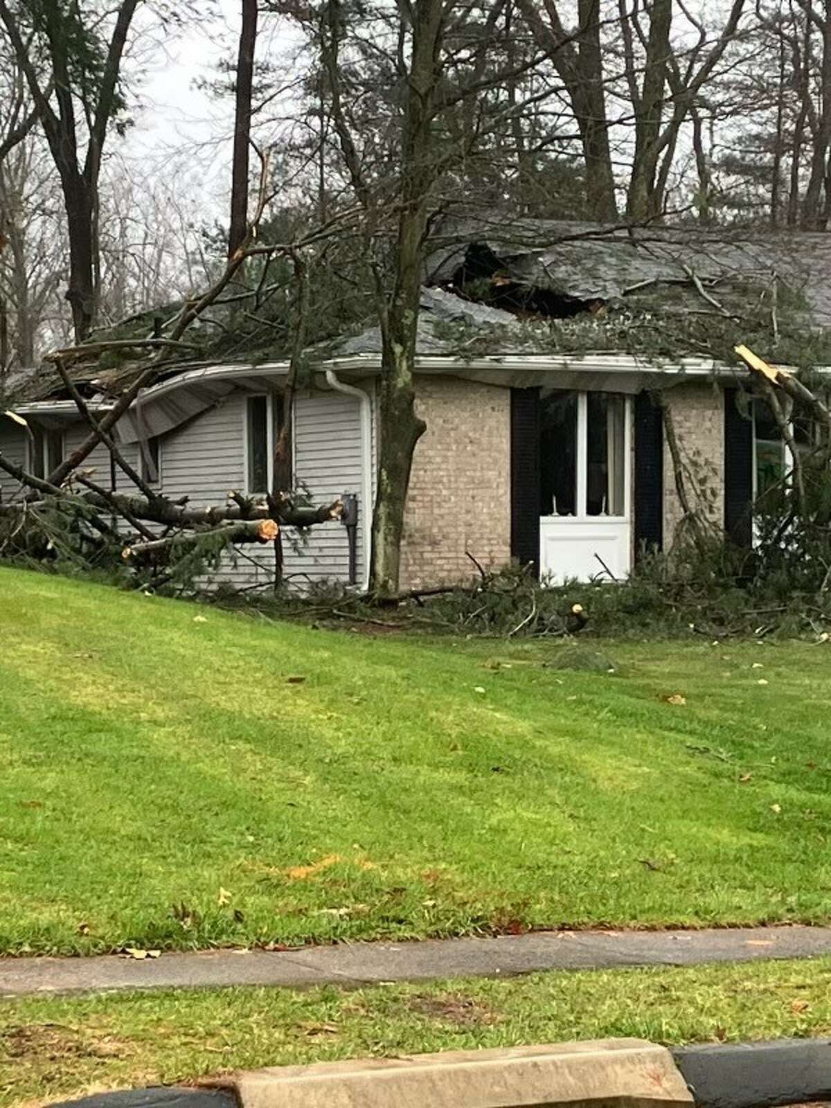
A tree fell and damaged a home on Berle Road in South Windsor as high winds and heavy rains swept across Connecticut Friday. No one was injured.
Jesse Leavenworth/Hearst Connecticut Media
In South Windsor, a tree fell on a home along Berle Road and punched a hole in the roof. The son of the homeowner said no one was injured.
Wolcott firefighters responded to a collapsed garage during the storm.
A tree also punched a hole in a home on Berle Road in South Windsor.
A tree hit an East Hartford home on Main and King Streets this morning and a portion of a building at Cheshire Academy collapsed during the storm.
Other towns are reporting no significant damage other than trees down causing power outages. Michael Maglione, Shelton’s director of Public Safety and Emergency Management, said the city has not experienced significant damage resulting from the heavy winds.
“We’ve done really, really well,” said Maglione, adding that power outages did not start coming into United Illuminating until after 4:30 a.m.
Deputy Fire Chief Paul Wilson also said there was no significant damage. He said there were a few trees on roadways, but nothing involving homes buildings. He added there have been calls about areas with live wires down.
Lamont’s office advised residents on Friday to avoid going to state parks due to downed trees.
Latest forecast
With the worst of the wind and rain subsided, temperatures will continue to fall as the night goes on.
Temperatures are forecast to drop into the teens or lower overnight, with gusty winds pushing the wind chill well below zero.
“Arctic air continues to rush into the region now that the cold front is offshore,” the weather service’s New York office said in a tweet at 5 p.m.
At Central Park, the temperature had fallen to 21 degrees with a wind chill of 7, a 10-degree drop from just two hours before, according to the weather service. The agency reported temperatures fell from 50 degrees at the New York office at 1 p.m. to 25 degrees by 5 p.m.
The bulk of the wind and rain has moved through the state by 9:30 a.m., according to the weather service. The strongest winds have ended with the state expected to see 35- to 40-mph gusts slowly abating to 25- to 35-mph gusts before the winds calm by Friday evening, Leatham said.
A severe thunderstorm warning was briefly issued for New London County and part of Middlesex County in eastern Connecticut Friday afternoon.
Although the roads are expected to be mainly dry by the time temperatures reach the freezing mark, any standing water may freeze, Leatham said. “There could be icy spots, but we don’t expect a widespread freeze on the roads.”
There could be a few showers Friday afternoon followed by snow showers in some locations as the temperatures drop, Leathem said. The transition to colder weather will start by noon with temperatures that are now in the 50s dropping to the 40s and below later in the day, he said.
A coastal flood warning was in effect until 1 p.m. Friday with tides up to 3 feet above normal, the weather service said.
“The potential for major flooding (3 feet of inundation above ground) on Friday morning will depend on gale force southeast winds and resultant high wave action occurring right through the time of high tide,” the weather service said. “If winds are weaker or shift more to the south southwest, moderate flood levels (2 feet of inundation) are more likely.”
A wind advisory is in effect until 10 p.m., the weather service said. Winds are expected to be between 20 and 30 mph with gusts up to mph, the weather service said.
“A brief period of damaging wind gusts up to 60 mph is possible,” the weather service said.
Early Friday the entire state was seeing wind gusts of 40 to 50 mph with the coast along Long Island Sound experiencing 55 mph winds, the NWS said.
The storm will leave behind extremely cold weather for the holiday weekend with overnight wind chills below zero and a high temperature on Saturday in the teens and low 20s, the weather service said.
Lamont has extended the state’s severe cold weather protocol through noon Tuesday. Shelters and warming centers are open throughout the state and anyone in need of a place to stay can call 211. Lamont’s office said transportation to the shelters will be provided.
Travel conditions
The storm has brought down trees and power lines, prompting local and state officials to warn motorists of the driving hazards.
Lamont’s office advised residents to stay home during the storm, but for those venturing out, updated road conditions can be found at CTroads.org.
There are 365 state trucks out treating roads around the state in addition to tree crews working to clear blocked roads, Josh Morgan, a spokesperson for the state Department of Transportation, said Friday afternoon.
Reports of roads closed or blocked due to downed trees and wires have been reported throughout the day around Connecticut.
State highway crews were not able to pre-treat the roadways because “the rain and the wind would just completely wash it away so it wouldn’t have any impact for Friday when those temperatures are going to drop,” Morgan said.
On Thursday, DOT crews were getting ready, making sure its trucks were fueled and loaded with salt, and its chainsaws, wood chippers and loaders were prepared to remove any downed trees or debris, Morgan said.
“We know something is coming we just don’t know how severe that will be,” he added. He said the agency will have digital signs up along Interstate 95 alerting drivers to the weather, and encouraged travelers to check the road conditions before heading out at the agency’s travel website.
Lamont’s office said public transit is still operating statewide, although there have been some delays and interruptions in service due to the storm. For those using public transportation, visit CTrail.com or CTtransit.com for bus updates.
The Metropolitan Transportation Authority said Thursday it was “pre-positioning crews and diesel locomotives” ahead of the storm.
“Additional personnel will be added this afternoon through the overnight hours to identify and quickly address possible track, signal and power challenges caused by flooding, washouts, downed trees and other potential storm damage,” the statement said Thursday. “Personnel will survey and clear drainage areas where necessary, fortify key locations, and look for trees requiring removal as well as any track structures requiring attention.”
Tweed New Haven Airport is open and reporting no delays as of 6:30 a.m., according to information supplied by Executive Director Sean Scanlon. Passengers can check here to find out the status of their flight.
Bradley International Airport is open. “At this time, we are not seeing any flight cancellations and approximately 15 percent of our flights are delayed,” a spokesperson for the airport said.
School closures
Many Connecticut school districts announced on Thursday classes would be canceled Friday in anticipation of the storm. Among the closures included schools in Bethel, Bridgeport, Danbury, New Haven, Norwalk, Seymour, Waterbury and West Haven.